2.4 Map Work & Locating Features
Lesson Progress
Not completed
Introduction
Navigation is what a pilot does when flying cross-country. The act of navigation allows the pilot to know where they are at all times, thereby avoiding airspace in which they are not allowed to fly and taking the correct actions in airspace where they are allowed to fly.
Pilotage is navigation by reference to landmarks only, and those landmarks are shown on the VNC. Being able to use a VNC to navigate is therefore tested on the HAGAR examination.
Pilots must be able to execute several tasks on a VNC chart for the HAGAR examination. Many of these are straightforward and not worth detailed discussion here. Some non-trivial topics have already been discussed in previous sections. In this lesson, we focus on what remains.
VNC Task Summary
| Task | How to |
|---|---|
| Identifying the location of a feature on the chart knowing the latitude and longitude of the feature | Locating a Feature on a VNC |
| Specifying the latitude and longitude of a feature on the chart | Locating a Feature on a VNC |
| Recognizing the various symbols on the map | Look at the legend |
| Identifying the altitude for each point on the chart | Depending on what is asked, use the elevation associated with the shading or the actual elevation of the feature shown on the map |
| Recognizing isogonic lines | 2.5 Magnetic Variation and Navigation |
| Identifying the magnetic deviation for each isogonic line on the chart | 2.5 Magnetic Variation and Navigation |
| Knowing how to set a compass to read true north for a point on the chart | 2.5 Magnetic Variation and Navigation |
| Identifying the airspace in which a particular point lies | See Section 2 |
| Identify airways, air routes, control areas, control area extensions, transition areas, TCA, aerodrome traffic zones and control zones and the airspace in which they are located | See Section 2 |
| Recognizing the altitude floor and ceiling for various airspace areas | See Section 2 |
| Determining obstacles along a given cross-country route between specified points | Look for the specific obstacle symbols (like towers or antennas) which will have their elevation listed in feet ASL and usually AGL in parentheses underneath. You would also look at the large bold numbers in the middle of each grid quadrangle (the Maximum Elevation Figure or MEF), which tells you the highest known feature (terrain or obstacle) in that specific square. |
| Calculating the distance between two points on the chart in nautical miles, statute miles or kilometers | Use a ruler to measure the distance between the two points and use the appropriate scale at the bottom of the VNC to determine the actual distance in the proper unit |
| Converting distances between nautical miles, statute miles and kilometers | Use a ruler and the scale at the bottom of the map |
| Identify the tower frequency for various aerodromes | Look at the legend to see where the information is shown and read it on the map |
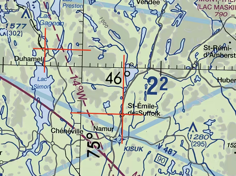
Locating a Feature on a VNC
Any point on Earth can be located by intersecting circles called parallels of latitude and meridians of longitude. These are called geographical coordinates.
- Longitude: Measured from 0° to 180° east and west of the Prime Meridian (numbered 0°, runs through Greenwich, England). The meridian on the opposite side of the globe is the antimeridian, which is used as the basis for the International Date Line.
- Latitude: Measured from 0° to 180° north and south of the Equator. The Equator is at 0°.
On a VNC, longitude and latitude are measured in degrees, minutes, and tenths of minutes. There are 60 minutes in a degree.
For example: N46°15.6’ W77°30.9’ means 46 degrees 15.6 minutes north of the Equator and 77 degrees 30.9 minutes west of the Prime Meridian.
On a VNC, parallels and meridians are represented by solid lines separated by 30’ (half a degree). The smallest graduation on these lines is one minute, so a tenth of a minute is very small on a VNC chart.
In the image below, we can see that the coordinates for the village of Duhamel are N46°1.4’ W75°4.8’ and the coordinates for the village of St-Emile-de-Suffolk are N45°55.9’ W74°54.8’.
This section clearly shows the degrees associated with a parallel and a meridian. These are not always as obvious everywhere on a VNC chart.